Know before you go
Before you ride, please familiarise yourself with the trail map and the following information.
Check the conditions and status of the trails here
GENERAL INFORMATION
- There is no drinking water available anywhere within the trail network. Public drinking water facilities are available in town;
- There are no toilets located at the trail head or anywhere within the trail network. Public toilet facilities are available in town;
- Riders are expected to stay on the trails and not take shortcuts;
- Riders are expected to take out anything they take in, including rubbish and food waste;
- George Town Council (or other landowners) may close the trails at short notice to undertake maintenance activities; if trail conditions are not fit for purpose; before, during or after extreme weather events; or at times of adverse fire weather conditions.
MOBILE PHONE COVERAGE
Mobile phone reception covers most of the trail network, but as the trails traverse many gullies, reception may be lost. All users are encouraged to carry a mobile phone and a trail map with them at all times.
BEFORE YOU GO RIDING
- Have the correct and adequate equipment for mountain biking, including a clean and functioning bike, a helmet, appropriate footwear and clothing suitable for current and possible weather conditions;
- Have a mobile phone with enough charge in case you need to call someone for assistance;
- Understand and exhibit basic trail etiquette. Have a read through our Code of Conduct, but most importantly just be friendly to others you encounter within the trail network;
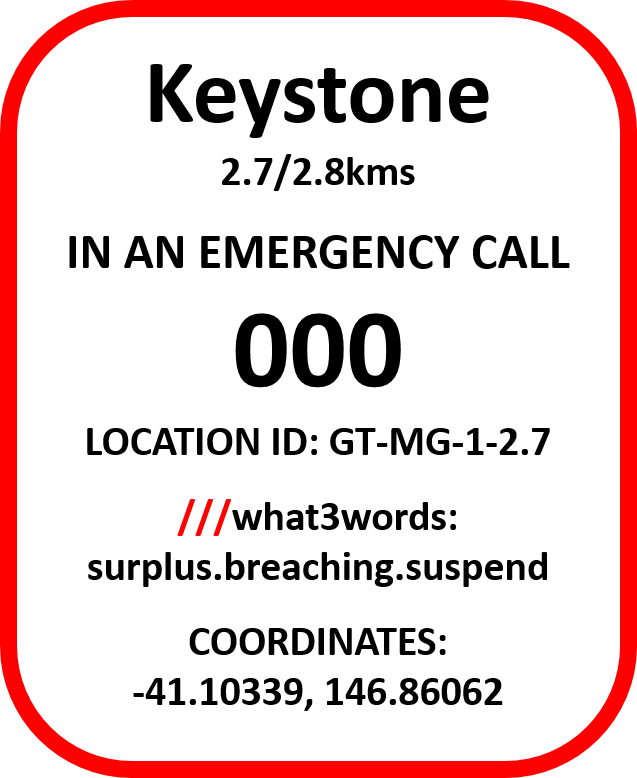
- Understand the function and how to interpret the Emergency Locator Signage;
- Check the trail conditions, closures, weather and fire conditions, and current bushfire advice;
- Inform a friend or family member where you are, what you are doing, and when you expect to finish.
UPLIFT SERVICES
Shuttles are simply the easiest way to get "Strait to the Top" and experience the descents without the pedalling, or to put it another way – all fun, no work.
Mount George is incredibly shuttle friendly on a sealed public road, and suitable for self-shuttling in you own vehicle. With an extremely quick turnaround, you can expect to be back at the top and shooting down the trails in less than five minutes. If you ride each trail once - seven shuttles, seven descents - you'll clock up 1,000m of elevation drop. No other trail network offers that kind of bang for your buck.
The Tippogoree Hills Trail Network is World Trail's freshest trail offering, with tech-flow, airflow, gravity and jump trails. The shuttle road is not publicly accessible. A shuttle trip to the summit drop-off point rewards you with a shortest possible descent of 5km!
Up Down and Around are the only MTB shuttle bus operator offering uplift services for both trail networks, and it's best to book in advance via their website - https://updownaround.rezdy.com.
CODE OF CONDUCT
Look after yourself: Ride within your capability,
wear the appropriate safety gear, and make sure you’ve told someone
where you are and when to expect you back. Make sure your bike is clean,
in good working condition, and you have all the spares needed for your
ride - including your phone in case you need to call for assistance.
Look after your mates: Look
out for each other on the trail, and help those that are in trouble. If
you need to overtake a rider, be patient, wait until it’s safe, and
alert the rider before doing so.
Look after the trails: Trails
are expensive to build and exist for your enjoyment. Respect the trail
builders and only ride on trails that are open, and only on the defined
trail tread - no shortcutting! If you see something requiring the
attention of the maintenance crew, report it to Council on 03 6382 8800
or on the website.
Look after the Environment: A
clean bike is not only a fast bike, it’s also crucial in keeping the
trail network weed and disease free. By simply ensuring your bike is
squeaky-clean before you ride, you’re playing an integral part in
helping stop the spread of weeds and disease.
CONDITIONS OF USE
By using the George Town Mountain Bike Trails, you acknowledge and agree to the conditions of use listed below: -
- Riders using the trails do so at their own risk and take full responsibility for their own safety;
- Wearing a helmet whilst riding a bicycle is compulsory in Tasmania, unless the rider has an exemption permit;
- All trails are one-way only, unless directed otherwise by trail signage;
- No dogs, horses or other pets are permitted on the trails;
- No smoking or alcohol is permitted anywhere within the trail network;
- No overnight parking or camping is permitted within the trail network or at the trail head carpark;
- No unauthorised vehicles, motor bikes or ATVs on any of the trails;
- No electric powered bikes greater than 200 watts without a pedal assist system on the trails.
EMERGENCY INFORMATION
IN THE EVENT OF AN EMERGENCY CALL 000
Alternatively, you can use the Emergency + app which uses the GPS on your smartphone to help you give the 000 phone operator your location. Download the Emergency+ app by scanning the QR code or by following this link. https://www.triplezero.gov.au/triple-zero/smartphone-applications |
|
OTHER USEFUL APPS///what3words is a platform that divides the world into 3m squares, with each square given a unique combination of three words. In using what3words you can easily give someone (including 000) your exact location. Download the what3words app by scanning the QR code or by following this link. https://what3words.com/products/what3words-app/. |
|
Trailforks is a trail map database to help you navigate your way around the trail network, using your phones GPS to geolocate your position onto the map. That means that wherever you are on the trails, Trailforks will pinpoint your location. Trailforks also offers information such as trail conditions and closures. Download the Trailforks app by scanning the QR code or by following this link. https://www.trailforks.com/apps/map/. |
Not an emergency, but still need help? The closet options are: -
George Town Medical Centre |
George Town District Hospital |
Launceston General Hospital |
Not sure if you need a hospital? The GP Assist Helpline can provide advice on 1800 022 222.
EMERGENCY LOCATOR SIGNSAlong the trails, you will notice bright red Emergency Locator Signs. The signs display a sticker indicating the trail name, how far along the total length of the trail the sign is, and location information of the sign, including the unique Location ID, what3words coordinates, and standard lat/long coordinates. This example sticker indicates the sign is located on the trail named “Keystone” at 1.2kms out of a total trail length of 2.7kms. If you need to call emergency services for yourself or a fellow trail user, head to the nearest sign by moving forward or backward along the trail until you find one (they’re every 500m at most). Call 000 and quote the Location ID, the what3words, or the coordinates to the operator so emergency services can locate you sooner. The sign locations are also marked on Trailforks as waypoints containing the same information as the stickers, providing a faster alternative to moving the physical sign location. |
 |
CONTACT DETAILS
For all maintenance issues, please call Council on 03 6382 8800 or log the issue on the webform in the REPORT AN ISSUE section, or on TrailForks.
DISCLAIMER
Undertaking sporting activities on the George Town Mountain Bike Trails can be dangerous and may result in injury or death to the person, and/or loss or damage of property. Users participating and/or spectating these activities do so at their own risk. To the extent permitted by law, George Town Council excludes all liability, including but not limited to liability for personal injury, death, property damage, property loss, and consequential loss or damage of any kind resulting from or attributable to the use of and/or entry to George Town Mountain Bike Trails, whether in contract, by negligent act or omission, or any other tortious action.
